Hidden Treasures of the Southern Carpathians: 3 Unforgettable Hikes in Romania

The Romanian Southern Carpathians, often called the Transylvanian Alps, are synonymous with wild, untamed nature and breathtaking mountain scenery. If you are looking for places where mass tourism has not yet fully made its mark and where you are more likely to meet animals than people on the ridges, you have come to the right place. We have prepared a selection of three unique hikes in the Făgăraș, Retezat, and Piatra Craiului mountains that will show you the very best of the Romanian mountains.
1. Făgăraș Mountains – The Royal Hike to Negoiu Peak (2535 m)
Forget the crowded Moldoveanu. The true gem and challenge of the Făgăraș is Romania's second-highest peak, Negoiu. This hike is the essence of high-altitude trekking – sharp ridges, technical sections, and views that will be etched into your memory.
- Why this hike? Negoiu is a majestic and awe-inspiring peak. The path to it leads over a beautiful ridge with exposed sections and offers dramatic views of the entire mountain range. Crossing the Strunga Doamnei saddle (a replacement for the permanently closed and dangerous Strunga Dracului) is an experience in itself. The area around Lake Călțun, where a bivouac shelter is also located, is one of the most photogenic spots in the Carpathians.
- Difficulty: High. The hike is technically and physically demanding, requiring experience in exposed terrain and stable weather.
- Duration: Approximately 10 – 12 hours, approx. 16 km. Elevation Gain: approx. 1500 m.
- Recommended period: June – September. In the early summer months, steep snowfields may be present on the trail.
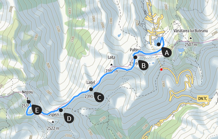
- Starting point and route: Bâlea Lake (2034 m), accessible by car via the famous Transfăgărășan highway.
-
-
Route: From Bâlea Lake, follow the red-stripe ridge trail westward. You will cross the Paltinului and Lăițel peaks, from where the first epic views of Negoiu will open up. Descend to the lake and Refugiul Călțun shelter. From there, a steep ascent continues through the Strunga Doamnei saddle to the summit of Vârful Negoiu. Return via the same route.
-
-
Parking: A large, paid parking lot is located directly at Bâlea Lake.
You can download the map by clicking on the image.
2. Retezat Mountains – To the Turquoise Eyes and Peleaga Peak (2509 m)
Retezat is rightly called "the land of blue eyes." It is home to over 80 glacial lakes, and this hike will take you to the largest and most beautiful of them all – Lake Bucura – and to the highest peak of the range.
- Why this hike? It is the perfect combination of everything that makes Retezat unique. A monumental glacial valley, crystal-clear lakes, green meadows full of flowers and marmots, and finally, a rocky summit with a panoramic view. By Lake Bucura, you will feel like you are in another world. The landscape changes from forest belt to vast meadows and finally to a raw, rocky wilderness.
- Difficulty: Medium to hard. It is not technically complex, but it requires good physical condition due to its length and elevation gain.
- Duration: Approximately 8 – 10 hours, approx. 18 km. Elevation Gain: approx. 1300 m.
- Recommended period: Late June – October.
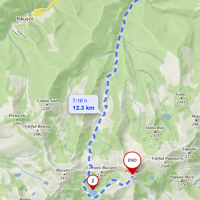
- Starting point and route: Poiana Pelegii (1630 m). The access road here may be in poor condition; a car with higher ground clearance is recommended.
-
-
Route: From the car park at the end of the road after the last village, Nucșoara. The route follows a comfortable path through the forest and later through dwarf pine, ascending gently to the huge glacial cirque where Lake Bucura (2040 m) is located. From the lake, continue on the yellow-stripe trail steeply up to the Curmătura Bucurei saddle and from there, along the rocky spine to the summit of Peleaga. Return via the same path.
-
-
Parking: Parking lot at the end of the road in Poiana Pelegii, after the village of Nucșoara.
You can view the map at this link.
3. Piatra Craiului Mountains – The Adrenaline-Fueled Traverse of the Limestone Ridge
If you are looking for something completely different, Piatra Craiului is the right choice. It is not a typical sprawling mountain range, but a single, 25 km long, narrow, and sharp limestone ridge resembling a knife's edge. This is a hike for true connoisseurs.
- Why this hike? Traversing this ridge is an unforgettable, adrenaline-pumping experience. You can expect exposed sections, easy climbing, chains in some places, and breathtaking views on both sides – with the Făgăraș on one side and the Bucegi mountains on the other. Thanks to its limestone base, unique flora grows here, including the endemic Piatra Craiului Pink (Garofița Pietrei Craiului). The landscape is dramatic, wild, and you are guaranteed not to encounter crowds.
- Difficulty: Very high, technically demanding. Intended exclusively for experienced hikers who are sure-footed, have no fear of heights, and possess good navigation skills.
- Duration: Ideally a two-day trek. Total of approx. 20-25 km, with significant ascent and descent.
-
-
Day 1 (approx. 6-8 hours): Ascent to the ridge and traverse of the southern part.
-
Day 2 (approx. 5-7 hours): Traverse of the northern part and descent.
-
- Recommended period: July – September. Absolutely unsuitable in rain, storms, or fog.
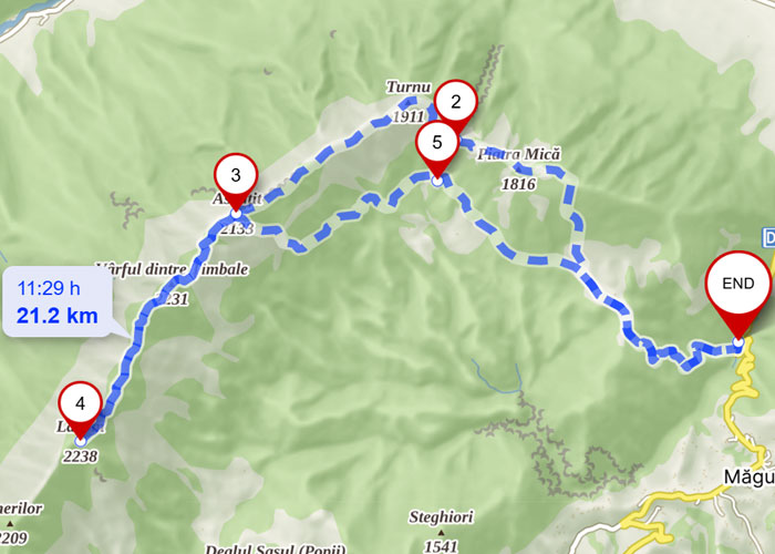
- Starting point and route: Fântâna lui Botorog (850 m) near the town of Zărnești.
-
Route (2 days): From Fântâna lui Botorog, ascend to the Cabana Curmătura hut (refreshments available). From there, climb steeply to the ridge via the Șaua Crăpăturii saddle (yellow-stripe trail). On the main ridge (red-stripe trail), continue south to the Refugiul Ascuțit bivouac, where you can spend the night. The next day, continue north along the ridge, cross the highest point La Om (2238 m), and descend via the technical section "La Lanțuri" (At the Chains) or an easier route back to the Curmătura hut and your car.
-
-
Parking: Parking is available at Fântâna lui Botorog or directly in the town of Zărnești.
You can download the map by clicking on the image.
What Not to Forget for the Romanian Mountains?
Preparation is key. The Romanian mountains are wild, and the weather changes quickly. Don't forget:
- Bear spray: The Romanian Carpathians are home to the largest population of brown bears in Europe. This is more of a precaution for your peace of mind.
- Reliable navigation: Trail markings can be sparse or damaged in places. A physical map, compass, and a GPS-enabled phone with offline maps are a must.
- Headlamp with spare batteries: Even on a day hike, you might be delayed.
- Water filter or purification tablets: There are many streams, but sheep often graze near them.
- Quality, layered clothing: A waterproof jacket and trousers are mandatory.
- Sturdy hiking boots.
- First-aid kit.
- Sun protection: Sunglasses, sunscreen, a hat.
- Sufficient food and water.
- Cash (cards are not accepted everywhere), ID, and mountain insurance.
I hope this selection has inspired you and that you will soon experience one of these beautiful hikes for yourself. The mountains are calling!